Reynisfjara Black Sand Beach
The basalt columns of Reynisfjara appear perfectly formed, almost sculpted by human hands.
Full story unlocks in the tour
 Andrea Schaffer / CC BY 2.0, via Wikimedia Commons
“Where volcanic drama meets the wild Atlantic.”
Not the postcards. The stories even locals don't know — whispered in your ear, right where they happened.
The basalt columns of Reynisfjara appear perfectly formed, almost sculpted by human hands.
The distinctive red-roofed church on the hill seems to offer a beacon of safety against the dramatic landscape.
The sheep you see grazing freely across the Icelandic landscape are more than just livestock.
Discover every secret of Vík
Every address, every reveal in full — in your ear, right where it happened.
You pick your stops. You walk. The voice reveals what the others miss.
No tours available yet. Check back soon — we're preparing them.
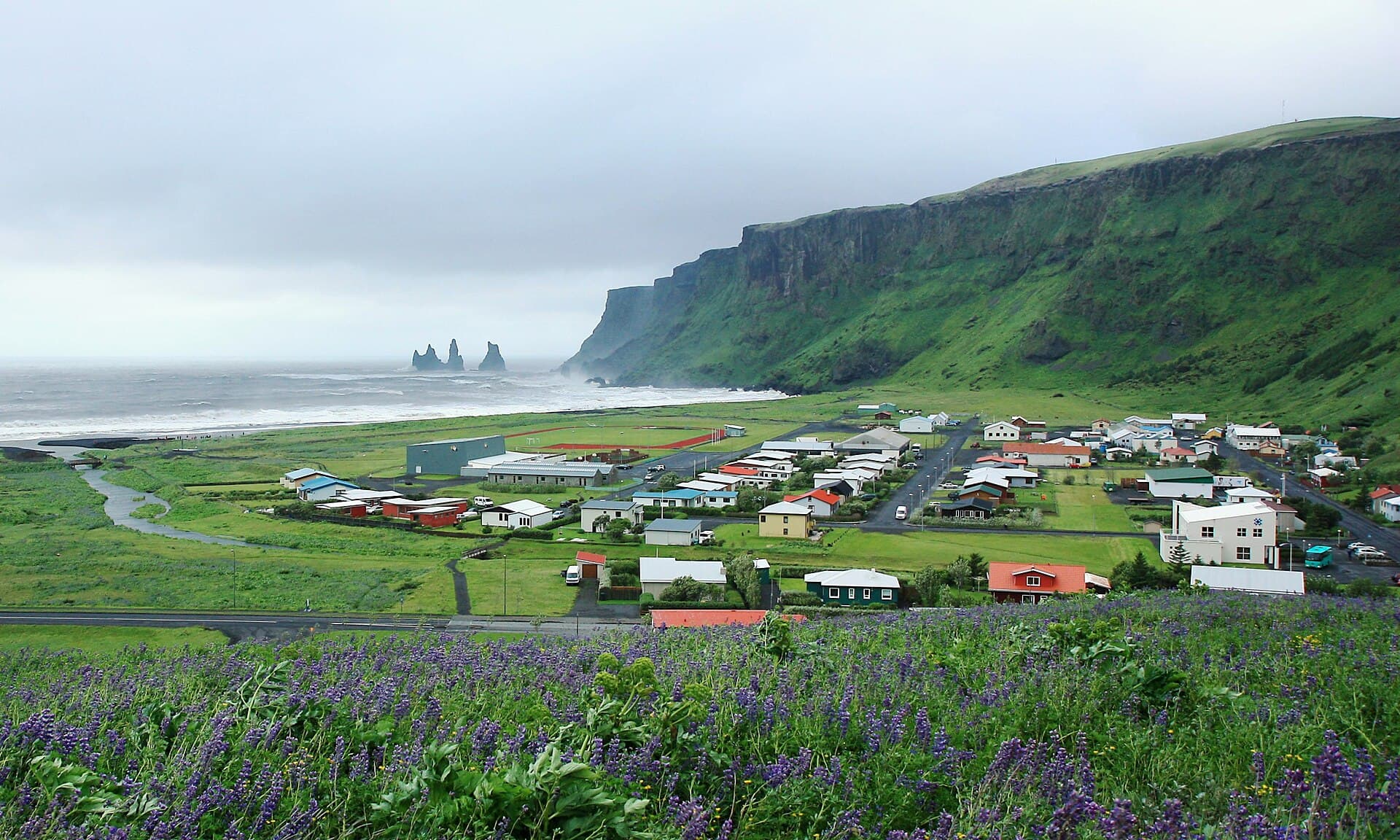
Vík í Mýrdal, often simply called Vík, stands as Iceland's southernmost village, a remote seafront settlement roughly 187 kilometers (116 miles) southeast of Reykjavík. Despite its modest population, estimated around 706 people in 2026, Vík serves as a pivotal service and tourist hub along the Ring Road, providing essential amenities like hotels, restaurants, and gas stations. The village's name, meaning "bay" in Icelandic, precisely describes its location amidst a striking backdrop of dark sand beaches, towering cliffs, and volcanic terrain.
Vík's appeal resides in its powerful natural surroundings, establishing it as a popular base for exploring the South Coast's marvels. It functions as a gateway to glaciers, waterfalls, and the formidable Katla volcano, which rests beneath the Mýrdalsjökull glacier. The area's distinct geology, shaped by potent volcanic forces and glacial activity, forges a landscape of unparalleled intensity and beauty.
While the village itself may not thrum with constant activity, its true draw lies just beyond the center, along the rugged coastline and dramatic natural landmarks that define this captivating region.
The history of Vík í Mýrdal stretches back to the 9th century, with initial Norse settlements occurring during this period. One of the first Norsemen to arrive in Iceland, Hjörleifur Hróðmarsson, a blood brother of Ingólfur Arnarson (often credited as the first permanent settler of Iceland), made his home near Vík. His farm, once surrounded by forests, was located about 10 kilometers west of the present-day village. Tragically, Hjörleifur met his end at the hands of his Irish slaves, who then fled to the Westman Islands, only to be pursued and killed by Ingólfur. Hjörleifur's burial mound can still be found atop Hjörleifshöfði.
Despite these early explorations, permanent trading settlements in Vík did not take root until 1890. Southern merchants established themselves here to sell essential goods like flour, vegetables, meat, salt, and sugar. Vík's development as a trading post was notable given its absence of a natural harbor, a unique characteristic for a seaside town in Iceland. Goods were initially transported by ship and horse until a road to Vík opened in 1939.
Vík's location is profoundly influenced by powerful geological forces. It sits between the Mýrdalsjökull glacier and the active Katla volcano. Katla is one of Iceland's most closely monitored volcanoes, with its last major eruption occurring in 1918. This eruption caused a significant glacial flood (jökulhlaup) that extended the coastline by two to three kilometers. The potential for future eruptions and subsequent floods has long shaped the community's awareness and preparedness.
In the early 20th century, as the local population grew, the need for a local church became apparent. The Vík í Mýrdal Church, with its distinctive red roof and white walls, was consecrated in 1934. Designed by Guðjón Samúelsson, Iceland's state architect, the church stands on a hill overlooking the village and the ocean, serving as both a spiritual center and a symbol of resilience.
Today, Vík is a flourishing tourist destination, drawing visitors with its dramatic landscapes and convenient location along the Ring Road. The village has embraced its unique environment, with attractions like the Icelandic Lava Show offering visitors a safe way to experience molten lava. The population of Vík and its surrounding municipality, Mýrdalshreppur, was around 750 in 2022, making it the largest settlement in the area. The influx of tourism has brought new opportunities, allowing Vík to thrive while maintaining its deep connection to its historical and geological roots.
Vík offers a concentrated dose of Iceland's dramatic South Coast scenery. The most iconic attraction is Reynisfjara Black Sand Beach, a short drive from the village. Here, jet-black volcanic sand meets powerful Atlantic waves, flanked by the impressive Reynisdrangar sea stacks—basalt columns rising grandly from the ocean, woven into local folklore as petrified trolls. The beach also features striking hexagonal basalt columns forming a cliffside cave. However, Reynisfjara is notoriously dangerous due to unpredictable "sneaker waves" and strong currents; visitors must stay well back from the waterline and heed all warnings.
Just west of Vík, the Dyrhólaey Peninsula is a 120-meter headland known for its natural rock arch extending into the sea. A lighthouse crowns the promontory, offering expansive views of the coastline. Dyrhólaey is also a significant birdwatching spot, particularly from mid-May to mid-August, when large colonies of puffins make their homes on its cliffs.
Overlooking the village is the charming Vík í Mýrdal Church (Víkurkirkja), with its white wooden exterior and bright red roof. This architectural landmark provides a picturesque contrast to the dark volcanic landscape and offers sweeping views of Vík, Reynisfjara, and the surrounding cliffs.
For a unique indoor experience, the Icelandic Lava Show in Vík allows visitors to safely witness molten lava flowing, recreating a volcanic eruption. Additionally, the Skaftfellingur Museum displays a 100-year-old ship and details the history of Icelandic boating and naval navigation. Nearby, the Sólheimajökull glacier tongue, about 30 minutes west of Vík, offers opportunities for glacier hikes.
The best time to visit Vík is during the summer months, from June to August. This period offers the mildest weather, longer daylight hours—including the phenomenon of white nights where it never gets completely dark—and ideal conditions for outdoor activities and puffin spotting at Dyrhólaey. While summer is generally warmer, Vík is also known as Iceland's wettest place, so waterproof layers are advisable year-round.
Winter, from December to February, presents a different kind of beauty, with opportunities to see the Northern Lights and experience guided ice cave tours on the Katla glacier. The shoulder months of May and September offer a balance of fewer crowds and decent weather.
Vík í Mýrdal is easily accessible via Route 1, the main Ring Road, approximately a 2.5-hour drive southeast from Reykjavík. This makes it a convenient stop for self-drive tours, allowing flexibility to explore attractions like Seljalandsfoss and Skógafoss waterfalls along the way. Public buses also operate between Reykjavík and Vík, particularly during summer.
Accommodation options in Vík range from hotels like Hotel Kría and Hotel Dyrholaey to the Black Beach Suites, offering views of Reynisfjara. The village provides essential services, including a supermarket, gas station, and a swimming pool. Dining choices include local restaurants serving traditional Icelandic cuisine, pizzas, and soups, often sourcing local ingredients.
Safety is paramount, especially at Reynisfjara Black Sand Beach. Always maintain a safe distance from the ocean, as "sneaker waves" are unpredictable and dangerous. Follow all posted warnings and avoid turning your back to the sea.